Shrewsbury could be hit by further flooding on Tuesday
Residents in parts of Ironbridge have now been asked to leave their homes as a danger to life critical incident was declared along the River Severn.
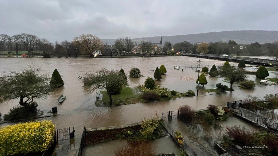
Water levels on the Severn north of Shropshire and over the Welsh border reached record levels with Storm Franklin following hot on the heels of storms Dudley and Eunice, and the torrent of water moving quickly downstream to Shrewsbury and Ironbridge Gorge.
In the county town some streets were under water and once again businesses in Coleham were submerged.
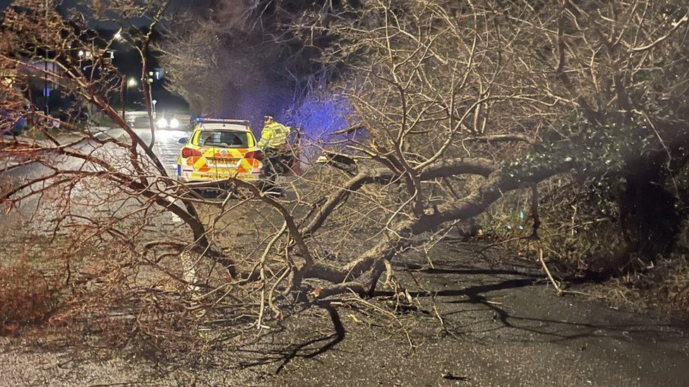
But it was in Ironbridge and further downstream at Bewdley where the Environment Agency upgraded the flood risk to severe with water at risk of topping the barriers along The Wharfage.
Residents of about 60 properties were asked to leave their homes and businesses.
Councillor Shaun Davies leader of Telford and Wrekin Council working with emergency services said it was vital that residents along the Wharfage leave their properties as there was a danger to life.
Ironbridge has been hit with a severe 'danger to life' flood warning
"The Environment Agency has declared a critical incident and we have make available hotel rooms so that people can be safe and warm over the next couple of days. There is a real risk that water levels will over top the barriers and we do know know what the effect of the force of the water would have on properties.
"This will be as bad as, if not worse than 2020, which, were were told, was a once-in-a-100-year event.
"Let's be safe rather than sorry. It is much better to have a night our two away from your home in the interests of the emergency services - who may not be able to come to your rescue should things go wrong."
Marc Lidderth, flood management spokesperson for the Environment Agency said: "What we are seeing is that the current forecast levels are going to be high and we could see the over-topping of the barriers which is why we issued the severe flood warning.
"The peak isn't probably going to be until Tuesday afternoon but the water is likely to top the barriers and we ask people to be vigilant and follow our social media messages and the advice given through the government website.
"If people choose not to leave we have advice and guidance on the website about protecting furniture and valuables and things precious to them but first and foremost we urge them to follow the evacuation advice as the decision isn't one that has been taken lightly."
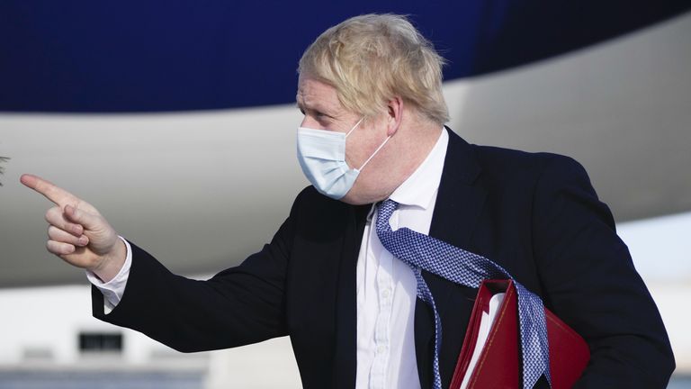
Boris Johnson overruled his health secretary as he announced the end of free coronavirus testing and told the nation to treat the virus like flu.
The prime minister said it was “time that we got our confidence back” as he confirmed that all Covid-19 laws would end in England on Thursday. People will no longer be legally required to isolate after a positive test but will still be advised to stay at home.
Sponsored
From April 1 most people will have to pay about £20 for a box of seven lateral flow tests. Only the very elderly and vulnerable will be given tests free of charge, as ministers promise to help to create a private market.
Johnson: Now it’s in your hands
The decision to end free tests came after Sajid Javid,
These individuals face a much higher risk from severe COVID-19, the JCVI said.
Advertisement
Therefore, another booster will be recommended for more than seven million people this spring.
Of these, half a million immunosuppressed people are eligible.
More on Covid-19
Related Topics:
Those advised to get a fourth jab in spring are:
• Adults aged 75 years and over
• Residents in a care home for older adults
• Individuals aged 12 years and over who are immunosuppressed, as defined in the COVID-19 healthcare guidance Green Book.
"The JCVI will keep under review whether the booster programme should be extended to further at-risk groups," Mr Javid said.
People aged over 18 will be given a 50mcg Moderna or 30mcg Pfizer/BioNTech vaccine, and eligible persons aged between 12 and 17 will be given a 30mcg Pfizer/BioNTech vaccine.
The UK already has enough vaccine doses ordered to cover the booster programme.
Wider booster programme planned for autumn
The JCVI has provided additional interim advice to ministers ahead of planning for a wider booster programme in autumn, which is likely to include people who are at higher risk of severe COVID-19.
No details on this have emerged yet - but the JCVI believes winter is likely to remain the season when the threat of COVID is the greatest.
Professor Wei Shen Lim, chair of COVID-19 vaccination on the JCVI, said: "Last year's booster vaccination programme has so far provided excellent protection against severe COVID-19.
"To maintain high levels of protection for the most vulnerable individuals in the population, an extra spring dose of vaccine is advised ahead of an expected autumn booster programme later this year.
"The JCVI will continue its rolling review of the vaccination programme and the epidemiological situation, particularly in relation to the timing and value of doses for less vulnerable older adults and those in clinical risk groups ahead of autumn 2022."
Many of us can expect an additional COVID vaccine before the year is out
Coming on the same day the Government is expected to lift all remaining COVID-19 restrictions, this announcement on the future of the vaccination programme is significant.
It demonstrates how vaccination is about to become our only formal defence against COVID and that even though the vaccine “wall” shows no signs of crumbling steps are being taken now to reinforce it.
Why boost now and not wait till the next wave, or the coming winter?
As we lift remaining restrictions like self-isolation, it’s uncertain how the epidemic will respond. Without routine testing, it might also be harder to see rapid changes in the spread of the virus. In other words, we’re heading into an uncertain time.
We can move forward without too much anxiety because boosters (for most people at third vaccine dose) provide around 90% protection from hospitalisation in the over-75s (by far the most vulnerable age group). However, we know that protection wanes.
The latest data shows that after 10 weeks that declines to about 88%. A tiny decrease, but in a vulnerable population, small numbers arithmetically can add up to big numbers statistically.
The decision to offer an additional spring booster is precautionary, insists the JCVI, to head off any waning of protection as we enter this more uncertain period.
We also learned today that an autumn booster would be offered, quite possibly for a larger proportion of the population, depending on what the data on vaccine protection is telling us as the year goes on.
It seems likely that by the end of the year many of us can expect to be offered an additional COVID-19 vaccine. That assumes of course, that the virus, and the way it spreads, stays the same. If recent history has taught us anything, however, it’s that we shouldn’t really assume anything.
'Living with COVID'
The announcement comes as Boris Johnson is expected to outline how England will "live with" the virus, as he considers dropping all remaining restrictions.
The prime minister will make a statement in the Commons at 4.30pm after meeting with his cabinet to discuss the plans.
Please use Chrome browser for a more accessible video player
2:14
PM criticised over COVID plans
On Saturday, Downing Street had confirmed that positive cases and their close contacts will no longer have to self-isolate by the end of this week.
The provision of free lateral flow tests could also end, following reports people would have to pay for them.
"Severe disruption" means Network Rail is advising customers to check before they travel on the railways.
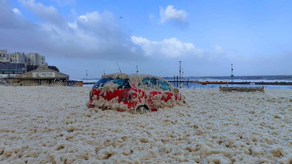
Franklin comes days after Storm Eunice killed three people and left 1.4 million homes without power.
The highest wind gust speeds on Monday morning reached 79mph in Capel Curig in Wales, and 78mph in Orlock Head, Northern Ireland. On Sunday night, 87mph was recorded at the Needles on the Isle of Wight.
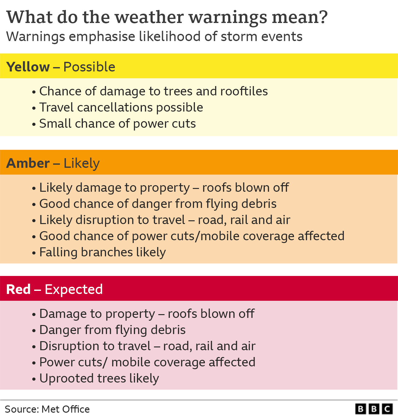
The Met Office issued two weather warnings for earlier on Monday: an amber warning for wind in Northern Ireland, and a milder yellow warning for wind covering Wales, Northern Ireland, most of England and parts of south-west Scotland.
Storm Franklin is the third named storm in a week - following Dudley and Eunice - the first time this has happened since the storm-naming system was introduced in 2015.
This video can not be played
To play this video you need to enable JavaScript in your browser.
More than 10,000 homes in the south east of England remain without power. Jane Rosam from Kent told the BBC her 100-year-old neighbour had been without power since Friday lunchtime.
"We are terrified that she will fall or get ill. The house is cold and the lack of care and concern from the power network is shamefully awful," she said.
In Devon and Cornwall, Caroline Bullock and her mother, 91, have been without power, heating, and drinking water since Friday and have been relying on friends to deliver food.
Energy minister Greg Hands said power outages were a "horrible thing" to happen to households and lessons would be learned for the energy network.
He said: "Quite often very significant lessons do get learned - the 105 emergency number for power outages was a lesson learned from a previous storm."
Manchester Airport diverted nine flights on Monday morning because of storm winds. It is understood the planes were holding to land before being diverted, but the airport says the weather has not affected departures.
British Airways has said winds have made it difficult to unload baggage from its planes - causing delays for passengers after landing. The airline has also struggled to land and restock planes on time, affecting inbound and outbound movements.
Elsewhere, the O2 arena in London will remain closed until Friday, when a UB40 concert is expected to go ahead as planned, after Storm Eunice shredded sections of the roof.
'I wouldn't rule out another named storm'
George Goodfellow, duty forecaster at BBC weather, says the forecast for the rest of the week is best described as unsettled: "We're expecting further spells of wet and windy weather for most of the coming week, and some parts of the UK will see strong winds at times.
"It looks as though the strongest winds will generally be towards the north west of the UK. Whether the winds will be strong enough to warrant the Met Office naming another storm is a bit uncertain.
"Warnings are usually issued based on the risk of disruption/hazardous weather, so I think the question is will it become significantly windier than normal. If so then warnings are likely, and I wouldn't rule out a named storm."
Storms have been more frequent in the last week because of a strong jet stream running across the Atlantic and the UK - the coming week sees the jet stream move "a little further north".
Orfhlaith Begley
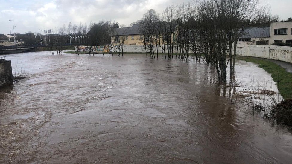
In Northern Ireland, heavy rain has caused severe flooding, with counties Londonderry and Tyrone the worst hit.
Northern Ireland Electricity said at the peak there were 10,000 homes without power during the early hours of Monday morning - that number has now fallen to around 330.
Russell Kennedy
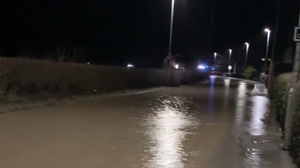
Parts of the River Severn and the Bristol Channel coast are on flood alert and emergency teams have erected flood barriers to try to stop the waters from reaching homes.
County councillor Karl Lewis said Llandinam in Powys, central Wales, had been left looking like a "disaster zone".
National Rail is advising customers to check their routes before travelling.
CrossCountry trains, which runs services from Aberdeen, through Birmingham and to the South West, is "strongly recommending" that people do not travel.
Network Rail
Great Western Railway (GWR) and South Western Railway joined CrossCountry trains and "strongly" advised against travel on Monday, and said disruption on routes are expected.
Southeastern railway withdrew its "do not travel" advice but warned its customers that they should expect delays and allow extra time for their journeys.
Chiltern Railways warned disruption will continue into Tuesday morning, "including trains and carriages being in the wrong places". It said customers should only travel on Monday "if their journey is absolutely essential".
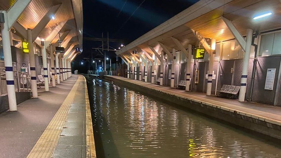
In West Yorkshire, the Thackley railway tunnel closed due to flooding.
And Rotherham Central station will remain closed until at least Tuesday - a picture shared by Leeds City Station on Twitter shows the extent of the track flooding.
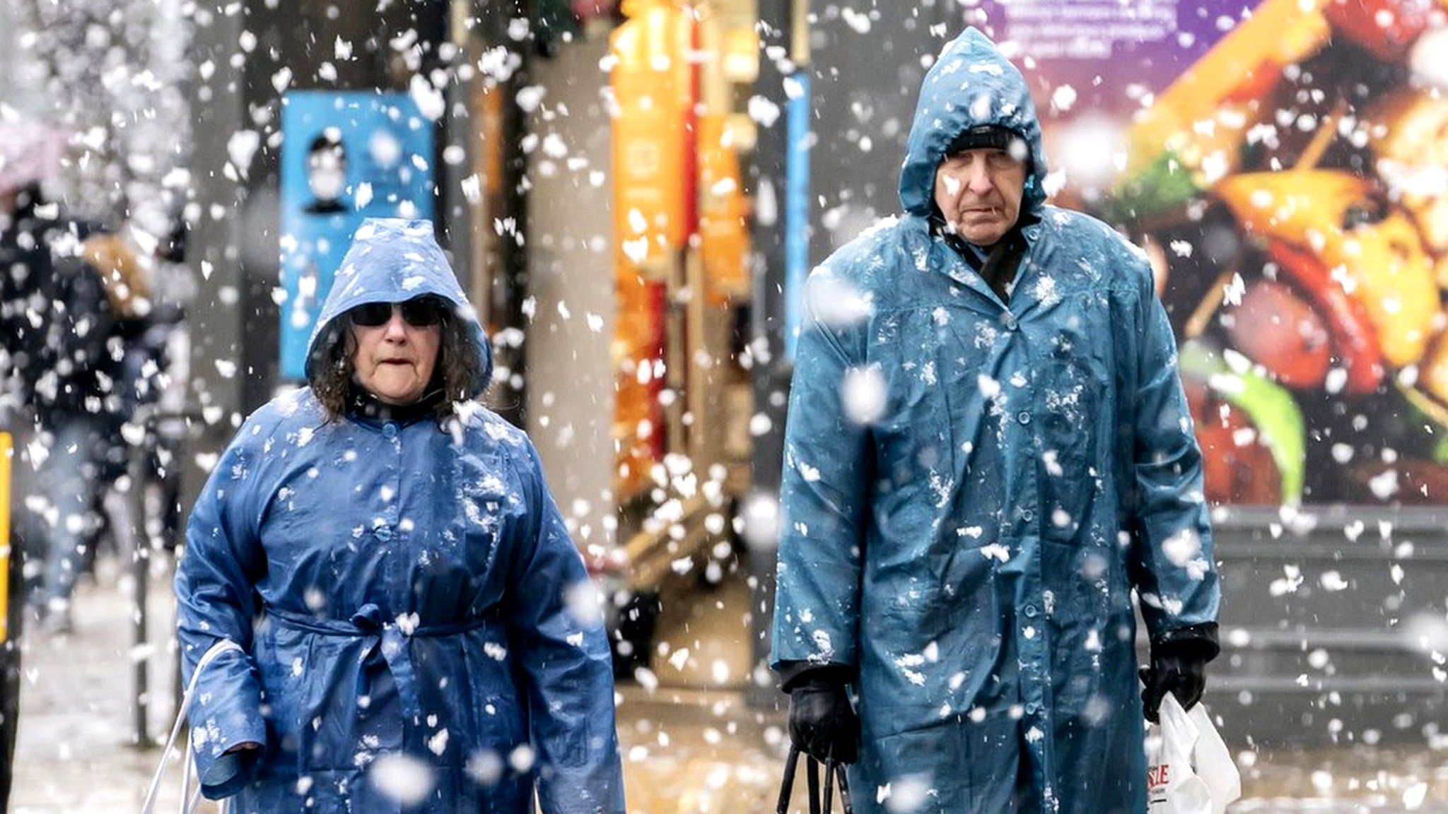
High winds could cause further power cuts, transport delays and damage to properties, the Met Office has warned.
Meteorologist Becky Mitchell told the PA news agency: "At the moment we've got a really active jet stream, which is why we're seeing so many storms track right towards the UK.
"We had Dudley on Wednesday, Eunice on Friday and Franklin today."
If you are reading this page and can't see the form you will need to visit the mobile version of the BBC website to submit your question or comment or you can email us at HaveYourSay@bbc.co.uk. Please include your name, age and location with any submission.
"Severe disruption" means Network Rail is advising customers to check before they travel on the railways.
Franklin comes days after Storm Eunice killed three people and left 1.4 million homes without power.
The highest wind gust speeds on Monday morning reached 79mph in Capel Curig in Wales, and 78mph in Orlock Head, Northern Ireland. On Sunday night, 87mph was recorded at the Needles on the Isle of Wight.
The Met Office issued two weather warnings for earlier on Monday: an amber warning for wind in Northern Ireland, and a milder yellow warning for wind covering Wales, Northern Ireland, most of England and parts of south-west Scotland.
Storm Franklin is the third named storm in a week - following Dudley and Eunice - the first time this has happened since the storm-naming system was introduced in 2015.
Over 33,000 homes are still waiting to be reconnected to power supplies following the earlier storms.
Energy minister Greg Hands said power outages were a "horrible thing" to happen to households and lessons would be learned for the energy network.
He said: "Quite often very significant lessons do get learned - the 105 emergency number for power outages was a lesson learned from a previous storm."
Manchester Airport diverted nine flights on Monday morning because of storm winds. It is understood the planes were holding to land before being diverted, but the airport says the weather has not affected departures.
British Airways has said winds have made it difficult to unload baggage from its planes - causing delays for passengers after landing.
The airline has also struggled to land and restock planes on time, affecting inbound and outbound movements.
Elsewhere, the O2 arena in London will remain closed until Friday, when a UB40 concert is expected to go ahead as planned, after Storm Eunice shredded sections of the roof.
'I wouldn't rule out another named storm'
George Goodfellow, duty forecaster at BBC weather, says the forecast for the rest of the week is best described as unsettled: "We're expecting further spells of wet and windy weather for most of the coming week, and some parts of the UK will see strong winds at times.
"It looks as though the strongest winds will generally be towards the north west of the UK. Whether the winds will be strong enough to warrant the Met Office naming another storm is a bit uncertain.
"Warnings are usually issued based on the risk of disruption/hazardous weather, so I think the question is will it become significantly windier than normal. If so then warnings are likely, and I wouldn't rule out a named storm."
Storms have been more frequent in the last week because of a strong jet stream running across the Atlantic and the UK - the coming week sees the jet stream move "a little further north".
More than 10,000 homes in the south east of England remain without power. Jane Rosam from Kent told the BBC her 100-year-old neighbour had been without power since Friday lunchtime.
"We are terrified that she will fall or get ill. The house is cold and the lack of care and concern from the power network is shamefully awful," she said.
In Devon and Cornwall, Caroline Bullock and her mother, 91, have been without power, heating, and drinking water since Friday and have been relying on friends to deliver food.
Orfhlaith Begley
In Northern Ireland, heavy rain has caused severe flooding, with counties Londonderry and Tyrone the worst hit.
Football pitches were left under metres of water in Castlederg, and 3,000 homes are still without power according to Northern Ireland Electricity (NIE).
NIE said at its peak there were 10,000 homes without power during the early hours of Monday morning.
Russell Kennedy
Parts of the River Severn and the Bristol Channel coast are on flood alert and emergency teams have erected flood barriers to try to stop the waters from reaching homes.
National Resources Wales (NRW) has issued 10 flood warnings, meaning flooding is expected, and 18 flood alerts, meaning it is possible.
County councillor Karl Lewis said Llandinam in Powys, central Wales, had been left looking like a "disaster zone".
The M48 Severn Bridge remains closed in both directions, as does the QE2 bridge at Dartford with long delays reported on both sides.
Elsewhere on the roads, in Greater Manchester, a stretch of the M60 has been closed because of an overturned HGV.
National Rail is advising customers to check their routes before travelling, with several companies expected to be affected.
CrossCountry trains, which runs services from Aberdeen, through Birmingham and to the South West, is "strongly recommending" that people do not travel.
Network Rail
Great Western Railway (GWR), CrossCountry, South Western Railway, and Southeastern railway are "strongly" advising against travel, with disruption on routes expected.
Chiltern Railways has warned disruption will continue into Tuesday morning, "including trains and carriages being in the wrong places"
In West Yorkshire, the Thackley railway tunnel has been closed due to flooding.
And Rotherham Central station will remain closed until at least Tuesday - a picture shared by Leeds City Station on Twitter shows the extent of the track flooding.
High winds could cause further power cuts, transport delays and damage to properties, the Met Office has warned.
Meteorologist Becky Mitchell told the PA news agency: "At the moment we've got a really active jet stream, which is why we're seeing so many storms track right towards the UK.
"We had Dudley on Wednesday, Eunice on Friday and Franklin today."
If you are reading this page and can't see the form you will need to visit the mobile version of the BBC website to submit your question or comment or you can email us at HaveYourSay@bbc.co.uk. Please include your name, age and location with any submission.